

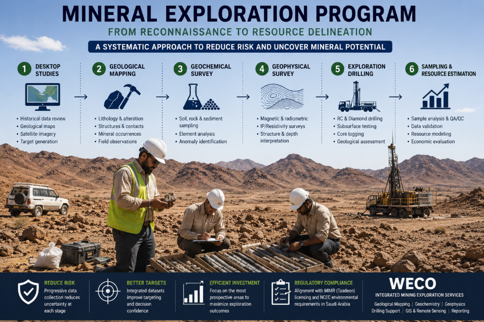
A mineral exploration program is a systematic process of developing an early geological concept into sufficient information to determine whether a mineral occurrence represents a viable investment opportunity. It typically progresses from desktop targeting and field mapping to geochemistry, geophysics, drilling, sampling, and resource evaluation. WECO provides integrated Mining exploration services in KSA to help companies progress from initial targets to technically defensible exploration decisions.
What is a Mineral Exploration Program?
Mineral exploration is not simply about drilling prospective ground. It is a progressive process designed to reduce uncertainty before increasingly costly decisions are made. This is especially important in the Precambrian Arabian Shield, which extends across western Saudi Arabia. The Shield is the main geological environment for much of the Kingdom’s metallic mineral potential, and the Saudi Geological Survey (SGS) provides geological, geochemical, geophysical, and mineral-resource information to support early-stage exploration targeting. A strong exploration program should be evidence-based, prioritize the most prospective targets, and provide clear justification for progressing to the next level of expenditure.
The Key Stages of a Successful Exploration Program
Exploration is best approached as a series of decisions, with each new dataset used to improve the design of the next activity.
| Stage | Main activity | Decision supported |
| 1 | Desktop studies | Where should fieldwork begin? |
| 2 | Geological Mapping | What geological controls are present? |
| 3 | Geochemical Survey | Where are anomalous mineral signatures? |
| 4 | Geophysical Survey | What targets may continue below surface? |
| 5 | Exploration drilling | What actually exists at depth? |
| 6 | Sampling and Resource Estimation | Is mineralization sufficiently continuous and significant? |
1. Desktop Studies: Use available information before deploying field crews. Large license areas can be narrowed down to priority corridors using historical exploration reports, SGS geological maps, satellite imagery, structural datasets, known mineral occurrences, previous drilling records, and regional geophysical data.
2. Geological Mapping: Lithology, alteration, structures, veins, contacts, and surface mineralization should be mapped in detail. Mineralization in the Arabian Shield may be controlled by shear zones, structural features, intrusions, and lithological contacts, making accurate structural interpretation particularly important. WECO’s geological services include field mapping, structural interpretation, GIS, satellite imagery analysis, and remote sensing.
3. Geochemical Surveys: A Geochemical Survey is used to determine whether soil, rock, sediment, or another sampling medium contains anomalous concentrations of target or pathfinder elements. Sampling should be based on geological reasoning rather than convenience, as the sampling strategy directly affects the reliability of the resulting data.
4. Geophysical Surveys: A Geophysical Survey identifies contrasts in physical properties that may indicate structures, alteration zones, sulphide mineralization, intrusive bodies, or other subsurface targets. Geophysical data can help refine targets before drilling and improve the positioning and orientation of drill holes.
5. Exploration Drilling: Drilling is an important method of obtaining direct subsurface geological evidence and typically represents a substantial increase in exploration expenditure. Reverse Circulation Drilling can provide an efficient sampling method for many reconnaissance and delineation programs. Diamond Core Drilling produces continuous core and is particularly useful when the preservation of structural relationships, alteration, mineralization controls, geotechnical information, or detailed geological logging is required. WECO currently provides drilling support services that include diamond core drilling, geological site mapping, core sampling, core logging, and technical geological assessments.
6. Sampling and Resource Evaluation: The drilling process does not end when the core or sample material reaches the surface. Samples must be correctly recorded, documented, secured, analyzed, validated, and interpreted. Resource Estimation may begin once sufficient information is available regarding geological continuity, grade distribution, deposit geometry, density, and other relevant characteristics.
Regulatory and Environmental Considerations
The mining licensing framework is administered by the Ministry of Industry and Mineral Resources (MIMR) through its Taadeen platform. The Exploration License process may require documentation including technical justification for site selection, evidence of financial capability, a proposed work program, proof of technical competence, and an environmental and social impact management plan. Before conducting field activities that require environmental permits or studies, environmental requirements should be assessed in coordination with the National Center for Environmental Compliance (NCEC). NCEC is responsible for environmental permitting and compliance with applicable Saudi environmental requirements.
How WECO Delivers Integrated Exploration Services
WECO’s published exploration services include geological mapping and structural interpretation, survey design, exploration planning, geological supervision, GIS and remote sensing, drilling support, technical reporting, geochemical analysis, field-data validation, and geological site assessment. WECO can also assist with the preparation, coordination, submission, and compliance requirements associated with mining licenses. Within project teams, these functions can be integrated to connect geological decisions with drilling priorities and Saudi regulatory requirements, thereby reducing the complexity of managing each discipline independently.
FAQs
What is a mineral exploration program?
A mineral exploration program is a staged series of investigations designed to identify, test, and progressively define a potential mineral deposit. It generally includes desktop research, geological mapping, geochemistry, geophysics, drilling, sampling, interpretation, and resource evaluation.
What are the steps in mineral exploration in Saudi Arabia?
A practical sequence includes desktop targeting, geological mapping, geochemical sampling, geophysical investigation, drilling, and progressively detailed resource evaluation. Saudi projects must also integrate Exploration License, environmental, access, and reporting requirements into the technical schedule.
Why is it necessary to carry out geological mapping before drilling?
Mapping identifies lithological contacts, alteration, structures, mineralized zones, and other geological controls that help geologists position and orient drill holes effectively. Drilling without an adequate geological model increases the risk of testing the wrong location or using an inappropriate drilling orientation.
How long does a typical exploration program take?
There is no fixed duration. Early reconnaissance may take several months, while systematic drilling and resource delineation may continue for several years. The schedule depends on factors such as license area, geology, seasonal conditions, access, permitting, laboratory turnaround times, drilling results, available budget, and how quickly targets can be prioritized or rejected.
What data should be reviewed before starting mineral exploration in Saudi Arabia?
Before fieldwork begins, exploration teams should review available geological maps, mineral occurrence records, geochemical and geophysical data, historical exploration reports, satellite imagery, and previous drilling information where available. The Saudi Geological Survey’s National Geological Database provides access to geological and exploration datasets that can support early target generation.
How do you choose drilling targets in the Arabian Shield?
Drilling targets should be selected by combining geological mapping with geochemical, geophysical, structural, and other exploration data rather than relying on a single anomaly. The aim is to identify targets where several independent datasets support the same geological interpretation, then test those targets through appropriately designed drilling.
Conclusion
Successful exploration is not defined simply by the number of meters drilled. Its success depends on whether each stage generates stronger evidence for the next investment decision. A disciplined program that integrates desktop analysis, field geology, geochemistry, geophysics, drilling, QA/QC, environmental planning, and resource evaluation can substantially reduce exploration uncertainty. Companies planning Mining exploration services KSA can contact WECO (Wealth Economics Company for Mining) for geological surveys, exploration planning, drilling support, and integrated technical services across Saudi Arabia.